
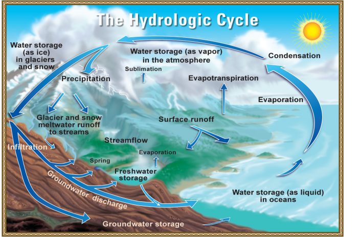
All people on Earth depend directly or indirectly on the ocean and cryosphere. The fundamental roles of the ocean and cryosphere in the Earth system include the uptake and redistribution of anthropogenic carbon dioxide and heat by the ocean, as well as their crucial involvement of in the hydrological cycle.
1. CRYOSPHERE:
The term “cryosphere” comes from the Greek word, “krios” which means cold which includes snow, ice, or both are key ingredients in every aspect of the cryosphere, including sea ice, glaciers, ice shelves, icebergs, and frozen ground.
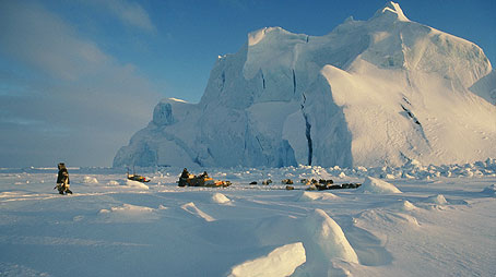
The cryosphere is the frozen water part of the Earth system. Beaufort Sea, north of Alaska, one part of the cryosphere is ice that is found in water. This includes frozen parts of the ocean, such as waters surrounding Antarctica and the Arctic. There are places on Earth that are so cold that water is frozen solid. These areas of snow or ice, which are subject to temperatures below 32°F for at least part of the year, compose the cryosphere. There are two parts of cryosphere:
- Ice and snow on land are one part of the cryosphere. This includes the largest parts of the cryosphere, the continental ice sheets found in Greenland and Antarctica, as well as ice caps, glaciers, and areas of snow and permafrost. When continental ice flows out from land and to the sea surface, we get shelf ice; and
- The other part of the cryosphere is ice that is found in water. This includes frozen parts of the ocean, such as waters surrounding Antarctica and the Arctic. It also includes frozen rivers and lakes, which mainly occur in polar areas.
The components of the cryosphere play an important role in the Earth’s climate. Snow and ice reflect heat from the sun, helping to regulate the planet’s temperature. Because Polar Regions are some of the most sensitive to climate shifts, the cryosphere may be one of the first places where scientists are able to identify global changes in climate.
Source: igbp.net
The cryosphere also amplifies climate changes through snow, ice and permafrost feedbacks. Services provided to people by the ocean and/or cryosphere include food and freshwater, renewable energy, health and wellbeing, cultural values, trade and transport.
The cryosphere refers to all frozen areas around the world. This includes:
- Snow: Snow makes up the second largest area of the cryosphere, covering over 18 million square miles. Most of this area is in the Northern Hemisphere and ranges from 17.9 million square miles in the winter to just 1.46 million square miles during the summer. Melting mountain snow coverage contributes most of the water to streams and groundwater around the world. This helps explain why mountains make up approximately 40 percent of global protected areas;
- Sea Ice: Large portions of the ocean near the north and south poles are covered in ice. In the Southern Hemisphere, sea ice covers between 6.56 million square miles and 7.7 million square miles in September. In February, this number can drop to as low as 1.15 million square miles. The seasonal variation is not so stark in the Northern Hemisphere. Sea ice in the Arctic region has been on a steady decrease of approximately 2.7 percent each 10 years from 1978 to 1995. From 1978 to 2012, that measurement changes to a 3.8 percent decrease. The Antarctic region, however, has indicated an increase of around 1.3 percent every decade;
- Freshwater Ice: Freshwater ice can be found in rivers and lakes. Typically, it is a seasonal occurrence and not usually found year-round, like sea ice. Because this ice coverage occurs per season and over a significantly smaller area, its effect on climate is minimal. Records of annual ice coverage and breakup can, however, indicate changes in global climate. This is particularly true of lake ice. River ice breakup is a less reliable source of climate change information because it is largely influenced by both changes to water flow and surrounding temperatures;
- Frozen Ground: Frozen ground includes areas with permafrost. In the Northern Hemisphere, frozen ground covers an area of around 20.84 million square miles. Areas of permafrost are not as easily measured, but estimates suggest it covers 20 percent of the land area in the Northern Hemisphere. In warmer seasons, the depth of frozen ground has been shown to influence both hydrologic and geomorphic events. The influence of permafrost, however, has yet to be identified. This is because permafrost consists of both ice and soil and rocks at freezing temperatures. The temperature of Alaskan permafrost has increased by 2.4°C over the last few decades; and
- Glaciers: Glaciers and ice sheets are considered part of the cryosphere. Both consist of large ice masses that sit on top of land. These ice masses melt, become thinner, and spread wider as they move across land. Approximately 77 percent of the world’s freshwater is found in ice sheets. The water in glaciers and ice sheets may remain frozen for between 100,000 and 1 million years. Researchers are still studying the effects of glaciers on global climate change. Currently, it is believed that they have little influence over global temperatures. However, glaciers have been melting at increased speeds over the last few decades. Estimates suggest that during the 20th century, these melting glaciers and ice sheets have contributed between 33% and 50% of the rise in sea levels.
2. OCEANS:
It wasn’t until 2000 that a fifth ocean was officially named: the Southern Ocean, which includes the waters around Antarctica. The world was divided into four parts: the Atlantic, Pacific, Indian, and Arctic oceans.
Evidence and understanding of the human causes of climate warming, and of associated ocean and cryosphere changes, has increased over the past 30 years of Intergovernmental Panel on Climate Change (IPCC) assessments. Human activities are estimated to have caused approximately 1.0°C of global warming above pre-industrial levels. Areas of concern in earlier IPCC reports, such as the expected acceleration of sea level rise, are now observed. Furthermore, significant sea level rise contributions from Antarctic ice sheet mass loss which earlier reports did not expect to manifest this century, are already being observed.
Oceans are world’s largest store of carbon as 83 percent of the global carbon cycle is circulated through marine waters. Oceans have a history of observing more than 90 percent of the heat from human-caused global warming and about one-third of carbon emissions. Consequently, oceans are being excessively impacted by increasing carbon dioxide (CO2) and other greenhouse gas (GHG) emissions from human activities.
Source: in.mashable.com
Oceans play a critical rule by:
- Covering 71 percent of the planet’s surface and making up 95 percent of all space available to life;
- Regulating the global climate, mediating temperature, driving the weather, and determining rainfalls, droughts, and floods; and
- Serving as a life-support system for Earth, and global commons that provides goods and services.
Here is a brief description of each ocean with the emphasis on the impact of climate change:
2.1 Pacific Ocean:
The Pacific Ocean is located between the Southern Ocean, Asia, and Australia in the Western Hemisphere:
- It is by far the world’s largest ocean at 60,060,700 square miles (155,557,000 square Km);
- It has an average depth of 13,215 feet (4,028 meters), but its deepest point is the Challenger Deep within the Mariana Trench near Japan;
- It covers 28 percent of the Earth and is equal in size to nearly all of the land area on the Earth; and
- This area is also the deepest point in the world at -35,840 feet (-10,924 meters).
The Pacific Ocean is important to geography not only because of its size but also because it has been a major historical route of exploration and migration.
Source: photokaz.com
Climate change is having a major impact on the islands and population of the vast Pacific Ocean, with its more than 7,500 islands and 9.2 million people being affected
in a number of ways.
As many islands are small and only a few metres above sea level they are prone to
flooding and salt water inundation, contaminating soil and drinking water. Most
communities depend on fishing as a major component of their diet and as sea
temperatures changes then fishing becomes more problematic.
Climate change is levitating several serious threats for many island nations in the Pacific Ocean which include threats to the existence of islanders:
- Sea level rise, due to the melting of continental ice sheets and the expansion of sea water as ocean temperatures slowly rise, threatens to drown low-lying islands, such as exist on the coral atolls of the Marshall Islands and French Polynesia;
- Rising sea surface temperatures and ocean acidification threaten corals; corals that generate the sediment these islands require to remain stable; and
- Changing climate circulation patterns affects the strength, duration, and paths of storms and precipitation events in the Pacific Ocean.
This in turn affects both the risk island populations face from extreme storms and the availability of the freshwater needed to sustain those populations.
2.2 Atlantic Ocean:
The Atlantic Ocean is located between African, Europe, and the Southern Ocean in the Western Hemisphere:
- The Atlantic Ocean is the world’s second-largest ocean with an area of 29,637,900 square miles (76,762,000 sq. km);
- The average depth of the Atlantic Ocean is 12,880 feet (3,926 meters) and the deepest point is the Puerto Rico Trench at -28,231 feet (-8,605 meters); and
- It includes water bodies such as the Baltic Sea, Black Sea, Caribbean Sea, Gulf of Mexico, Mediterranean Sea, and the North Sea.
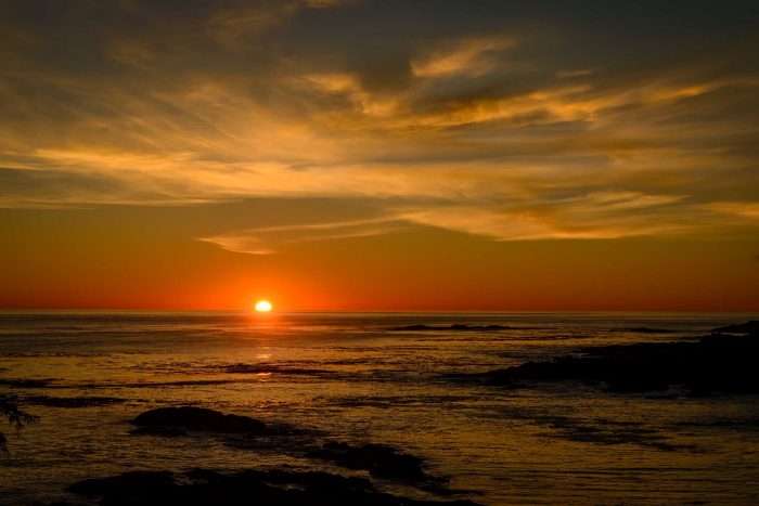
The Atlantic Ocean is important to the world’s weather (as are all oceans) because strong Atlantic hurricanes often develop off the coast of Cape Verde, Africa and move toward the Caribbean Sea from August to November.
Source: justfunfacts.com
As global temperatures continue to rise, there has been a stubbornly cool patch of ocean in the North Atlantic that has intrigued scientists for years. Global warming is likely slowing the main Atlantic Ocean circulation, which has plunged to its weakest level on record, according to a new study. The slowdown in the circulation — a crucial part of Earth’s climate — had been predicted by computer models, but researchers said they can now observe it. It could make for more extreme weather across the Northern Hemisphere, especially Europe, and could increase sea level rise along the US East Coast, they said. The slowdown also raises the prospect of a complete circulation shutdown, which would be a dangerous “tipping point,” according to a study in Wednesday’s journal Nature.
Scientists blame global warming in the following ways.
Warmer water lessens the amount of cooling and makes it harder for the water to sink and turn over. Ice sheets and glaciers in Greenland are melting and the fresh water is pouring into the area where the water turns over, making it less salty, less dense and therefore less likely to sink. There’s also more rain and snow in northern areas and more evaporation in southern areas, altering the flow, Rahmstorf said – “It’s a slow change at the moment, but we’re changing it,” Caesar said. “One danger is in the unknown of what will happen. We should expect changes.”
2.3 Indian Ocean:
The Indian Ocean is located between Africa, the Southern Ocean, Asia, and Australia:
- The Indian Ocean is the world’s third-largest ocean and it has an area of 26,469,900 square miles (68,566,000 sq km);
- The Indian Ocean has an average depth of 13,002 feet (3,963 meters) and the Java Trench is its deepest point at -23,812 feet (-7,258 meters); and
- The waters of the Indian Ocean also include water bodies such as the Andaman, Arabian, Flores, Java, and the Red Sea, as well as the Bay of Bengal, Great Australian Bight, Gulf of Aden, Gulf of Oman, Mozambique Channel, and the Persian Gulf.
The Indian Ocean is known for causing the monsoonal weather patterns that dominate much of Southeast Asia and for having waters that have been historical chokepoints (narrow international waterways).

Source: World Atlas
Global warming is approaching a tipping point that during this century could reawaken an ancient climate pattern similar to El Niño in the Indian Ocean, according to new research by scientists at the University of Arizona, the University of Texas at Austin and the University of Hawai‘i at Manoa. If it comes to pass, floods, storms and drought are likely to worsen and become more regular, disproportionately affecting populations most vulnerable to climate change.
Global heating is “supercharging” an increasingly dangerous climate mechanism in the Indian Ocean that has played a role in disasters this year including bushfires in Australia and floods in Africa. Scientists and humanitarian officials say this year’s record Indian Ocean dipole, as the phenomenon is known, threatens to reappear more regularly and in a more extreme form as sea surface temperatures rise.
Recent research suggests ocean heat has risen dramatically over the past decade, leading to the potential for warming water in the Indian Ocean to affect the Indian monsoon, one of the most important climate patterns in the world. There has been research suggesting that “Indian Ocean dipole events have become more common with the warming in the last 50 years, with climate models suggesting a tendency for such events to become more frequent and becoming stronger.
2.4 Southern Ocean:
The Southern Ocean extends from the coast of Antarctica to 60 degrees south latitude. The world’s largest ocean current, the Antarctic Circumpolar Current, moves east and is 13,049 miles (21,000 km) in length:
- The Southern Ocean is the world’s newest and fourth-largest ocean;
- The Southern Ocean has a total area of 7,848,300 square miles (20,327,000 sq km) and an average depth ranging from 13,100 to 16,400 feet (4,000 to 5,000 meters); and
- The deepest point in the Southern Ocean is unnamed, but it is in the south end of the South Sandwich Trench and has a depth of -23,737 feet (-7,235 meters).
In the spring of 2000, the International Hydrographic Organization decided to delimit a fifth ocean. In doing so, boundaries were taken from the Pacific, Atlantic, and Indian Oceans.
Source: scentofpine.org
The Southern Ocean plays a fundamental role in global climate. With no continental barriers, it distributes climate signals among the Pacific, Atlantic, and Indian Oceans through its fast-flowing, energetic, and deep-reaching dominant current, the Antarctic Circumpolar Current. The unusual dynamics of this current, in conjunction with energetic atmospheric and ice conditions, make the Southern Ocean a key region for connecting the surface ocean with the world ocean’s deep seas. Recent examinations of global ocean temperature show that the Southern Ocean plays a major role in global ocean heat uptake and storage. Since 2006, an estimated 60 percent–90 percent of global ocean heat content change associated with global warming is based in the Southern Ocean. But the warming of its water masses is inhomogeneous
According to tos.org: The Southern Ocean is a central component of the global ocean heat uptake, of Earth’s energy imbalance, and of global warming. Its complex circulation, which connects all ocean density layers to the sea surface, makes it a unique place on Earth to facilitate the transfer of heat from the atmosphere to great depths, where the heat is stored for decades to millennia.
The Southern Ocean is also changing rapidly. Observations over several decades indicate that the water is warming, freshening, decreasing in oxygen and acidifying. The system is also producing about half the amount of Antarctic Bottom Water than it was in 1970. The ability of the Southern Ocean to continue to provide ‘services’ that slow the rate of climate change is unknown. Equally uncertain are the potential climate effects if the rate of carbon and heat absorption in the Southern Ocean begin to slow.
2.5 Arctic Ocean:
The Arctic Ocean extends between Europe, Asia, and North America. Most of its waters are north of the Arctic Circle:
- The Arctic Ocean is the world’s smallest with an area of 5,427,000 square miles (14,056,000 sq km);
- Its average depth is 3,953 feet (1,205 meters) and its deepest point is the Fram Basin at -15,305 feet (-4,665 meters); and
- The Northwest Passage and the Northern Sea Route have historically been important areas of trade and exploration.
Throughout most of the year, much of the Arctic Ocean is covered by a drifting polar icepack that is an average of ten feet (three meters) thick. However, as the Earth’s climate changes, the Polar Regions are warming and much of the icepack melts during the summer months.

Source: National Geography
Churchill perches on the seacoast within the Hudson Bay Lowlands, North America’s largest wetland. The area’s most famous inhabitants are its some 57,000 beluga whales and 1,000 polar bears; Churchill advertises itself as both the beluga whale and the polar bear capital of the world. However, global climate change is threatening this landscape and the wildlife that resides there. Churchill has warmed approximately two degrees Celsius since record keeping began in the 1880s, resulting in a myriad of ecological changes, such as shrinking polar sea ice, retreating glaciers, and less snowpack that melts earlier.
Arctic amplification is not the only evidence of rapid climate change in the Arctic. The floating sea ice cover of the Arctic Ocean is shrinking, especially during summer. Snow cover over land in the Arctic has decreased, notably in spring, and glaciers in Alaska, Greenland, and northern Canada are retreating. In addition, frozen ground in the Arctic, known as permafrost, is warming and in many areas thawing. Scientists first started to see evidence of changes in Arctic climate in the 1980s. Since then, the changes have become much more pronounced.
Changes in the Arctic climate are important because the Arctic acts as a refrigerator for the rest of the world—it helps cool the planet. So changes in the Arctic climate could affect the climate in the rest of the world. Changes in the Arctic have effects that cascade through the food chain, from phytoplankton to marine mammals such as seals, walrus, whales, and polar bears.
Kanata, Ontario, Canada 16 August 2020